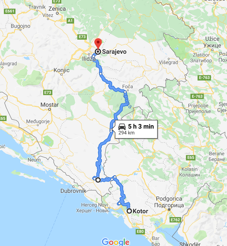
Being on the road to Sarajevo from Kotor was some of the most surprisingly beautiful scenery we had enjoyed yet. We were ready to go, having spent a day in Kotor not doing much. It took about an hour to wind our way out of the Bay of Kotor (Brendan was driving today), and start to climb north through smaller Montenegrin mountains to a vista overlooking the bay. Then we continued to wind to the border crossing with Bosnia and Herzegovina. This crossing was pretty reasonable, but still took 30 minutes. And also this time, no random 5 Euro fee in bills and not coins on the entry in to Bosnia.
We did alter our route slightly to what Google recommended as the fastest time to try to avoid a fairly mountainous and minor looking road in Montenegro, opting instead to head due west towards Bosnia. This put our border crossing earlier on the route. Unfortunately, the border crossing took a while as well – it wasn’t staffed to the level it needed to be to handle traffic, and it was confusing in that there were multiple lanes that eventually all merged together, giving people an opportunity to cut (which they did). It took us more than an hour.
In retrospect, continuing north on the road from Kotor to Bosnia probably would have been fine – but we were done blindly following Google. The route we chose on the road to Sarajevo had consistently good roads, although all one lane each way.
In retrospect, continuing north on the road from Kotor to Bosnia probably would have been fine – but we were done blindly following Google. The route we chose on the road to Sarajevo had consistently good roads, although all one lane each way.

After about another hour driving through the Bosnian countryside of rocky limestone hills and watching shepherds tend to their flocks, we started to climb and see some really stark mountains in front of us. We had previously wondered whether Bosnia & Herzegovina had any real mountains – question answered. This was the part of being on the road to Sarajevo from Kotor that we enjoyed the most. And it turned out that we went right through a national park containing the largest mountain in Bosnia in the Dinaric Alps (the highest peak of the Dinaric Alps is actually in Albania). Maglić Mountain in the Sutjeska National Park that we drove through (and saw!) and is the tallest in Bosnia and Herzegovina and comes in at 7,828 feet.
The Sujetska National Park was established in 1963 by Tito and is the oldest national park in Bosnia. This park is also famous for the Battle of Sujetska, where the Germans were defeated in 1943 by Marshal Tito and his partisan forces. There is a white abstract monument to memorialize this event, and it can be seen from the road.
The park itself is 43,000 acres and took us maybe 90 minutes to drive through. Along the way there were several police checkpoints where we were asked to pull over, but ultimately were waived through. We counted three checkpoints total on the road to Sarajevo. We later ask our Sarajevo guide what this was all about, and he had no idea – but they obviously weren’t looking for bribes from foreigners (we did have a Croatian licence plate).
The road to Sarajevo and through this national park was probably our favorite drive for the entire trip through the Balkans. It was so interesting to observe Soviet looking alpine retreats, camps, and villages dotting the drive – and a clear eye towards preservation, as well as a demonstration of a love of nature by the Bosnian people. We saw people hiking, white water rafting, and climbing throughout our voyage through. We wondered how clear the park was of land mines.
After clearing the mountains, we continued to experience hilly and windy terrain on the remainder of the road to Sarajevo. Agriculture finally began to emerge as the rocky limestone topography was left behind. It took us another 90 minutes or so once out of the park to come in to Sarajevo, and then we hit gridlock on the road from the airport to the city. We did get to bass by many interesting sites along the way, including some signs of the Olympics (Sarajevo hosted the winter Olympics in 1984) as well as Soviet block architecture building after building that were all in disrepair. There were some bombed out buildings as well, we presume from the Siege of Sarajevo. Our first impression of Sarajevo was bleak. We continued on the road to the old city, our hotel being just at the north entrance, which we fortunately found easily by obeying Google’s instructions.
Unfortunately we didn’t take any pictures on the road to Sarajevo from Kotor, Montenegro, but you can check out the website to the Sujetska National Park for an idea of the beauty. This was a fabulous drive, and takes about 5 hours as long as you don’t hit traffic in Sarajevo or any construction detours along the way (we hit a little of everything).
